
Case Studies
Thermal survey of a small sporting estate.
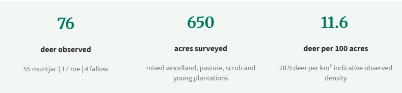
In March 2026, Veltris completed a thermal aerial deer survey for a small sporting estate in Berkshire. The brief was to establish an objective baseline of deer presence, spatial distribution and indicative density across approximately 650 acres of mixed habitat, supporting evidence-led estate management, habitat protection and sporting decision-making.
Survey Overview.
The survey combined systematic lawn-mower transects with focused inspection of key woodland blocks, plantation areas and boundary features. Post-flight review followed a detect-identify-confirm workflow, with footage reviewed independently by two analysts to reduce duplicate counting and improve classification confidence. The resulting estate figure should therefore be read as a disciplined, management-facing baseline rather than an absolute census.
What the survey revealed.
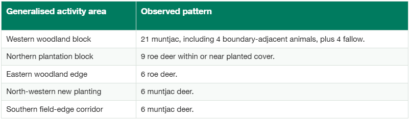
Muntjac were numerically dominant. The strongest concentrations were associated with woodland blocks, edge habitat and new planting, while roe activity was notably associated with plantation cover. The report established a quality-assured observed estate total of 76 deer, including a limited number of immediately boundary-adjacent detections where spatial association with estate habitat was clear. The figure materially exceeded the pre-survey working estimate by almost 100%, underlining the value of thermal evidence where sightings alone may understate presence.
Management value.
The immediate value of the work lay in giving the estate a clearer operational picture of where management attention should be concentrated and in establishing a repeatable evidential baseline against which sightings, cull returns, camera data, habitat-impact evidence and future surveys can be assessed.It also corrected a materially low prior estimate: the observed total was approximately double the level anticipated before the survey. The report therefore provided a stronger basis for prioritisation, monitoring and proportionate, evidence-led management review, rather than relying on impressions from inconsistent ground encounters alone.
What the case study shows.
For sporting estates and land managers, thermal aerial survey can do more than produce imagery. In this case it resolved a practical perception gap: deer numbers had been assessed at roughly half the figure later observed, with inconsistent ground encounters contributing to an understated view of estate-wide presence. The survey converted that uncertainty into a clearer, evidence-derived management baseline.